Difference between revisions of "Waikouaiti Whaling Station"
(→Excavation) |
(→Excavation) |
||
| Line 29: | Line 29: | ||
===Area A=== | ===Area A=== | ||
| − | Area A was established at the location of two possible building terraces. A | + | Area A was established at the location of two possible building terraces. A 2x2m unit was initially opened up at the beginning of excavation. The top layer turned out to be a large area of midden with both European and Maori cultural artifacts. Faunal material included fishbones, especially barracuda (Thyrsites atun) and possibly groper (Polyprion oxygeneios). Shell fish found included blue mussel (Mytilis edulis aoteanus), cockle (Chione stutchburyt) and pipi (Paphies australis). All of these species are common to the area and normally found at Maori sites. Other faunal remains included those of one lamb. An additional 2x2m unit was opened that revealed slump in the stratigraphy. This proved to be be a characteristic of the erosion occuring in the area and no cultural layers were found. |
===Area B=== | ===Area B=== | ||
Revision as of 16:02, 21 February 2010
The Waikouaiti Whaling Station is an early historic site located in New Zealand. It was established in 1837 by Long, Wright, and Richards and sold a year later to Johnny Jones. The whaling station served as a processing center for whale blubber and oil after the whales were captured and killed in the nearby harbor. As an archaeological site, the whaling station provides good evidence for the contact period between Europeans and the Maori, the indigenous Polynesian peoples of the area. Excavation was conducted in November 1992 by Matthew Campbell.
Contents
Location
| Waikouaiti whaling station is located in a town called Karitane at the mouth of the Waikouaiti River, 34km North of the city of Dunedin. The city itself is situated within the Otago Region of New Zealand. The river stretches into a salt water lagoon that empties into the sea. This area was deep enough for whales to come into the harbor and made the cliffs along the coast an ideal location for an industrial area focused on whaling. | <googlemap lat="-45.638287" lon="170.654755" zoom="13" height="250" scale="yes" controls="large">
-45.641943, 170.657135, Karitane, Otago, New Zealand </googlemap> |
History
| The Waikouaiti Whaling Station was originally established in 1837 by a group of men named Long, Wright, and Richards. After their company failed the following year, it was sold to Johnny Jones. Jones is accredited for bringing Europeans to the region and establishing the city of the same name that is present today. In 1840, the first settlers arrived aboard the "Magnet." About 100 Europeans were living and farming in the area at the time. Traditional domesticates included chicken and sheep. In addition, 120 Maori lived in a nearby pa, a village or settlement. Archaeology of this area has shown that contact occurred between the groups. Historical accounts of the station describe agricultural fields and cottages along the shore where most of the workers lived. The station continued on through the 1870s during the whaling revival when the Maori built a ship of their own. |
Excavation
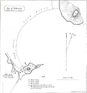
Historical sketches show that the industrial whaling area was to the Northern side of Huriawa Peninsula. Descriptions claim the try-works was further toward the isthmus in several sheds and the whaling shears were closer to the harbor. The site was first surveyed in 1844 by Davison. His sketches formed the basis of the work that Campbell and his crew conducted in 1992.
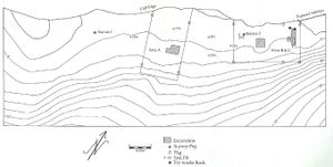
| The site itself was surveyed as part of the October/November 1990 site survey done of whaling stations along the southern coast and includes only the industrial center. Being along the coast, the site had been subjected to harsh weather and was beginning to erode. The cliffs were slumping down, distorting stratigraphy and leaving voids in the earth. As excavation began, the location of the try-works was based on a 1899 photograph taked by Maus. They were thought to be up on a terrace, about 50 x 15m in size and 1.5m from the edge, on a cliff at the northeast end of the site. However, this proved to not be the case. The signal staff was located on a high point of the peninsula. Around the area was historic and prehistoric terracing, but this was distorted and also enhanced by the erosion and slumping occuring in the area. It was also located in an area enclosed by the Huriwa Pa in the 18th century. In November 1992 excavation of the site began. The area was mapped with a theodolite and electronic distance meter. The excavation itself was split into three areas. |
Area A
Area A was established at the location of two possible building terraces. A 2x2m unit was initially opened up at the beginning of excavation. The top layer turned out to be a large area of midden with both European and Maori cultural artifacts. Faunal material included fishbones, especially barracuda (Thyrsites atun) and possibly groper (Polyprion oxygeneios). Shell fish found included blue mussel (Mytilis edulis aoteanus), cockle (Chione stutchburyt) and pipi (Paphies australis). All of these species are common to the area and normally found at Maori sites. Other faunal remains included those of one lamb. An additional 2x2m unit was opened that revealed slump in the stratigraphy. This proved to be be a characteristic of the erosion occuring in the area and no cultural layers were found.
Area B
Area C
Summary of Results
While the excavation of the whaling station was informative, Campbell and his crew did not find much beyond supportive evidence that a whaling industrial center had once existed along the coast.
Sources
- "North of Dunedin," Te Ara: The Encyclopedia of New Zealand. Te Ara
- Campbell, Matthew 1993. The Excavation of Waikouaiti Whaling Station (I43/66); A report to the New Zealand Historic Places Trust. University of Orago.

