|
|
| Line 47: |
Line 47: |
| | | | |
| | | | | | |
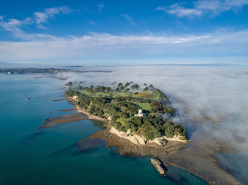
| − | == Panorama == | + | ==Aerial View == |
| | | | |
| − | | + | [[File:Musick_Pt.jpg]] |
| − | <html><iframe frameborder="0" src="http://photosynth.net/embed.aspx?cid=3be7d816-ee67-403f-830d-58d223494933&delayLoad=true&slideShowPlaying=false" width="500" height="300"></iframe></html>
| |
| − | | |
| − | Panorama of the small pa the the northern tip of the site showing pits and terraces.
| |
| | | | |
| | |} | | |} |
Revision as of 18:27, 2 December 2022
Musick Point Pa
| SITE TO VISIT
|
| Musick Point Pa
|
| Te Waiarohia
|

|
 
|
| Ethnicity:
|
Maori
|
| Site type:
|
Pa - fortification
|
| Where:
|
Eastern side of the Tamaki Eastury
|
| How to get there:
|
30 minutes from the city
|
| How Long to allow:
|
1 Hour
|
| Disclaimer
|
Location:
Loading map...
{"minzoom":false,"maxzoom":false,"mappingservice":"leaflet","width":"600px","height":"400px","centre":false,"title":"","label":"","icon":"","visitedicon":"","lines":[],"polygons":[],"circles":[],"rectangles":[],"wmsoverlay":false,"copycoords":false,"static":false,"zoom":16,"defzoom":14,"layers":["OpenStreetMap"],"overlaylayers":[],"resizable":false,"enablefullscreen":false,"scrollwheelzoom":true,"markercluster":false,"clustermaxzoom":20,"clusterzoomonclick":true,"clustermaxradius":80,"clusterspiderfy":true,"locations":[{"text":"\u003Cb\u003E\u003Cdiv class=\"mw-parser-output\"\u003E\u003Cpre\u003EMusick Point Pa\n\u003C/pre\u003E\u003C/div\u003E\u003C/b\u003E\u003Chr /\u003E\u003Cdiv class=\"mw-parser-output\"\u003E\u003C/div\u003E","title":"Musick Point Pa\n","link":"","lat":-36.84768900000000257932697422802448272705078125,"lon":174.901399999999995316102285869419574737548828125,"icon":""}],"imageoverlays":null}
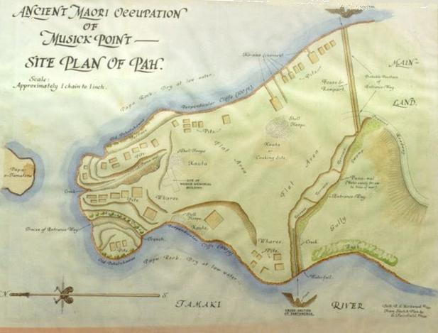 Map of the pa in its original form |
What:
Large headland pa - highly modified but with still some evidence remaining.The site is named after pioneer Pacific aviator Ed Musick.
|
Aerial View
|
Web Info:
https://www.aucklandcouncil.govt.nz/parks-recreation/get-outdoors/aklpaths/Pages/path-detail.aspx?ItemId=30
http://en.wikipedia.org/wiki/Musick_Point
What else to do there:
Visit the Art Deco Aeradio Station building.


