|
|
| Line 20: |
Line 20: |
| | }} | | }} |
| | | | |
| − | <googlemap lat="-36.890948" lon="174.839129" zoom="16">
| + | |
| − | 37.804372, -122.270803, Oakland, CA, USA
| + | {{#display_map: |
| − | -36.84846, 174.763332, Auckland, New Zealand
| + | -36.892081, 174.83943~ Maungarei Stonefields; |
| − | -36.892081, 174.83943, Maungarei Stonefields
| + | | height= 400px |
| − | </googlemap>
| + | | width= 600px |
| | + | | type=satellite |
| | + | | zoom=16 |
| | + | }} |
| | + | [[Category:Museum]] |
| | + | [[Category:Auckland]] |
| | + | |
| | + | |
| | | | |
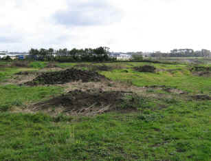
| | [[File:Stonefields.jpg|framed| Stone heaps from garden clearing dominate the site]] | | [[File:Stonefields.jpg|framed| Stone heaps from garden clearing dominate the site]] |
| | + | |
| | == What: == | | == What: == |
| | | | |
Revision as of 20:48, 4 August 2013
Maungarei Stonefields
Location:
| SITE TO VISIT
|
| Maungarei Stonefields
|
| -
|

|

|
| Ethnicity:
|
Maori
|
| Site type:
|
Garden
|
| Where:
|
Northwest of Mt Wellington / Maungarei. Reserve off Tidey Road
|
| How to get there:
|
30 minutes from central Auckland
|
| How Long to allow:
|
30 minutes at the site.
|
| Disclaimer
|
Loading map...
{"minzoom":false,"maxzoom":false,"mappingservice":"leaflet","width":"600px","height":"400px","centre":false,"title":"","label":"","icon":"","visitedicon":"","lines":[],"polygons":[],"circles":[],"rectangles":[],"wmsoverlay":false,"copycoords":false,"static":false,"zoom":16,"defzoom":14,"layers":["OpenStreetMap"],"overlaylayers":[],"resizable":false,"enablefullscreen":false,"scrollwheelzoom":true,"markercluster":false,"clustermaxzoom":20,"clusterzoomonclick":true,"clustermaxradius":80,"clusterspiderfy":true,"locations":[{"text":"\u003Cb\u003E\u003Cdiv class=\"mw-parser-output\"\u003E\u003Cpre\u003EMaungarei Stonefields\n\u003C/pre\u003E\u003C/div\u003E\u003C/b\u003E\u003Chr /\u003E\u003Cdiv class=\"mw-parser-output\"\u003E\u003C/div\u003E","title":"Maungarei Stonefields\n","link":"","lat":-36.89208099999999745932655059732496738433837890625,"lon":174.8394299999999930150806903839111328125,"icon":""}],"imageoverlays":null}

Stone heaps from garden clearing dominate the site
What:
Newly created reserve with a remnant of the formerly extensive stonefields gardens that once surrounded Mt Wellington volcanic cone. The adjacent suburb Stonefields is named on recognition of this.
Web Info:
http://www.stonefields.co.nz/StonefieldsTheName.aspx

