Summary
Site U13/4 The adjacent swamp site has the same site number but is not discussed here. NZMS1 site No, N53–54/5.
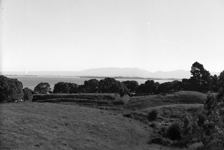 The pa in the 1960s
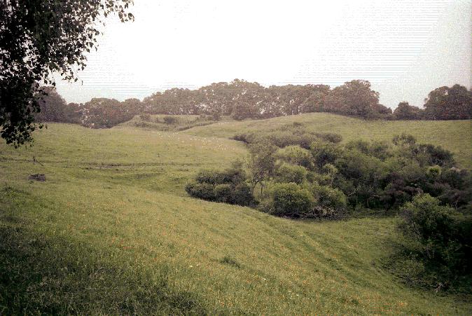 The site in 2006
The site was carefully chosen as one likely to help elucidate the development of Maori culture. The reasons are discussed by Golson [1]
"The site presents today as a ring ditch pa and excavation has demonstrated that this was its form in much of the past as well, though a greater area had been enclosed at one intermediate
phase. The exterior bank and ditch had been rebuilt in the course of the occupation.
The interior of the pa site was a mass of intercutting pits. The earliest evidence on the site was of pits capped by a garden soil that pre-dated the first fortification. The pits varied in size from 6 m long down to small ‘bin’ pits. Ambrose (1967) made the case, now generally accepted, that they were constructed for kumara storage, and had short lives before being infilled because of the risk of tuber-rotting fungus spores accumulating in them. He also suggested that fires were lit in the empty structures to fumigate them
between uses.
Use of the site for gardening was followed by construction of terraces that were used for cooking and for storage pits. A shell midden is associated with this use. The first ditch defences enclosed the majority of the site and were contemporary with a late stage of the deposition of this midden. A double ditch was used on areas of lower relief, and a single ditch where it was steeper. The inner side of the earthwork defences was palisaded. The ditch was later filled with midden and then the site was re-fortified on a smaller perimeter with a recut single ditch. The last stage of defence following this was construction of a double ditch around the smaller perimeter site, with a palisade along the inner bank and in the base of the outer ditch. The outer ditch was V-bottomed, and the inner was flat-bottomed. Ambrose (1967), in
noting the density of pits in the area where there was evidence of three phases of defence structures, concluded that the main purpose of the pa was defence of what was being stored in the pits." [2]
|
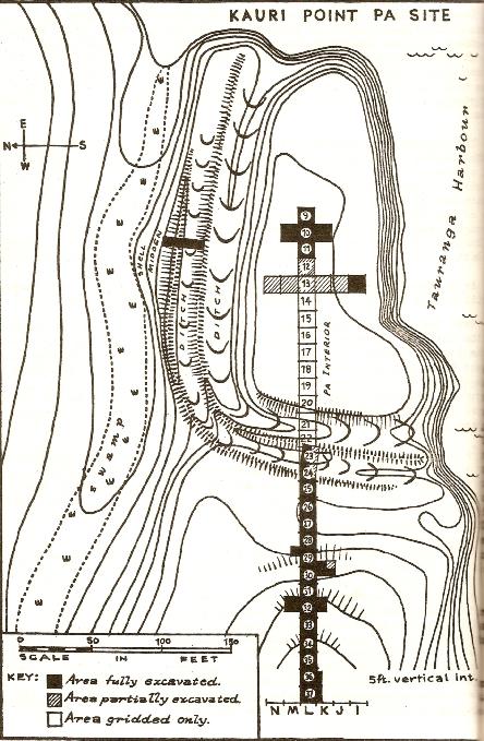 The site map in the first season's excavation report. References
- ↑ Golson, J. 1961a: Investigations at Kauri Point, Katikati, western Bay of Plenty: introduction. New Zealand Archaeological Association Newsletter 4(2): 13–15.
- ↑ p61, Law R G 2008 Archaeology of the Bay of Plenty Department of Conservation Publication 246, Wellington.
|
|
Auckland University Matipihi has a large sequence of photographs from this site Link. The pictures here are linked from there, the captions come from there and the pictures have links to their reference pages.
Other photographs can be accessed at a different University of Auckland photo archive site here.
|
Location and Date
On the Katikati Peninsula in the Tauranga Harbour, Bay of Plenty.
Loading map...
{"minzoom":false,"maxzoom":false,"mappingservice":"leaflet","width":"600px","height":"400px","centre":false,"title":"","label":"","icon":"","visitedicon":"","lines":[],"polygons":[],"circles":[],"rectangles":[],"wmsoverlay":false,"copycoords":false,"static":false,"zoom":17,"defzoom":14,"layers":["OpenStreetMap"],"overlaylayers":[],"resizable":false,"enablefullscreen":false,"scrollwheelzoom":true,"markercluster":false,"clustermaxzoom":20,"clusterzoomonclick":true,"clustermaxradius":80,"clusterspiderfy":true,"locations":[{"text":"\u003Cb\u003E\u003Cdiv class=\"mw-parser-output\"\u003E\u003C/div\u003E\u003C/b\u003E\u003Chr /\u003E\u003Cdiv class=\"mw-parser-output\"\u003E\u003C/div\u003E","title":"","link":"http://archaeopedia.com/wiki/index.php/Kairi_Point_Pa","lat":-37.5167550000000034060576581396162509918212890625,"lon":175.97165499999999838109943084418773651123046875,"icon":""}],"imageoverlays":null}
Excavations took place in 1960-61, 1961-62 and 1967(Ambrose pers. com.).
Type
Pa site - prehistoric
Excavators
Project Directors
Jack Golson
Archaeologists
Wall Ambrose
University of Auckland Archaeological Society
Other contributing specialists
Alan Pullar, J C Schofield
Site workers
These included Les Groube, Janet Davidson, Dave Simmons, Lawrie Birks.
Artefacts
Obsidian flake material was common at the site. Artefacts have not been reported on for the site.
Publications
Excavation Report
Only preliminary reports have appeared.
Ambrose, W. 1962: Further Investigations at Kauri Point. New Zealand Archaeological Association
Newsletter 5(1): 56–67.
Ambrose, W. 1967: Kauri Point. Unpublished manuscript presented at New Zealand Archaeological
Association Conference, New Plymouth.
Golson, J. 1961a: Investigations at Kauri Point, Katikati, western Bay of Plenty: introduction. New Zealand Archaeological Association Newsletter 4(2): 13–15.On-line
Golson, J. 1961b: Investigations at Kauri Point, Katikati, western Bay of Plenty: the excavation. New Zealand Archaeological Association Newsletter 4(2): 17–29.On-line
Golson, J. 1961c: Investigations at Kauri Point, Katikati, western Bay of Plenty: conclusions and hypotheses. New Zealand Archaeological Association Newsletter 4(2): 38–41.On-line
Other Papers
The chronology of the site and the adjacent swamp site was summarised by Green [1].
Law's review of the archaeology of the Bay of Plenty reviewed the evidence from the site [2]
Palmer, R.L. 1994 A Comparative Analysis Between Kauri Point Pa and Swamp Site Obsidian Collections. M.A. Research Essay, University of Auckland.
Davidson, J.M. 1967 Midden analysis and the economic approach in New Zealand. Records of the Auckland Institute and Museum.
References
- ↑ Green, R.C. 1978: Dating the Kauri Point sequence. Historic Review 26(1): 32–45.
- ↑ Law, R G 2008 Archaeology of the Bay of Plenty Department of Conservation Publication 246, Wellington.
 The pa in the 1960s
 The site in 2006


