Difference between revisions of "Ambury Regional Park"
| Line 1: | Line 1: | ||
[[Category:Location]] | [[Category:Location]] | ||
| − | '''Location''' | + | ''' |
| + | == Location == | ||
| + | ''' | ||
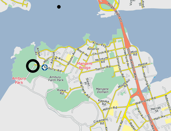
Ambury Regional Park is located just 15 kilometers from Central Auckland and rests on the ash-covered lava flow from Mangere Mountain. | Ambury Regional Park is located just 15 kilometers from Central Auckland and rests on the ash-covered lava flow from Mangere Mountain. | ||
| Line 6: | Line 8: | ||
---- | ---- | ||
| − | '''Summary''' | + | ''' |
| + | == Summary == | ||
| + | ''' | ||
| + | Nearby Mangere Mountain was once the site of large fortified Māori pa and the area now known as Ambury Regional Park was used by Māori for gardening. Mangere Mountain erupted approximately 18,000 years ago and the park sits atop a lava field made fertile by ash from the volcano. The Archaeological record left behind is astounding and, for the most part, can be viewed by the public. In fact, Ambury Regional Park is the only place where publicly owned [[http://archaeopedia.com/wiki/index.php/Maori_Rock_Art]] can be found. | ||
| + | |||
| + | ---- | ||
| + | |||
| + | == Archaeology == | ||
| + | In 1981 over 95 separate archaeological sites were recorded. These mostly included | ||
Revision as of 10:11, 22 February 2010
Location
Ambury Regional Park is located just 15 kilometers from Central Auckland and rests on the ash-covered lava flow from Mangere Mountain.

Summary
Nearby Mangere Mountain was once the site of large fortified Māori pa and the area now known as Ambury Regional Park was used by Māori for gardening. Mangere Mountain erupted approximately 18,000 years ago and the park sits atop a lava field made fertile by ash from the volcano. The Archaeological record left behind is astounding and, for the most part, can be viewed by the public. In fact, Ambury Regional Park is the only place where publicly owned [[1]] can be found.
Archaeology
In 1981 over 95 separate archaeological sites were recorded. These mostly included