Difference between revisions of "Ambury Regional Park"
(→Archaeology) |
(→History) |
||
| Line 30: | Line 30: | ||
== History == | == History == | ||
| − | + | Approximately one kilometre south-west of Ambury Regional Park is Puketutu | |
| − | + | Island. This island is also known as "Motu-a-Hiaroa" (Island of the Long | |
| − | The area | + | Desired) and is claimed to have been populated by some of the earliest Maori |
| − | + | inhabitants of Aotearoa i as far b. ack as 950 A.D.- | |
| − | + | Tradition has it that one of the earliest travellers from Hawaiki (generally | |
| − | + | thought to be the Society Islands), Toi-te-hua-tahi, also known as Toi-kairakau, | |
| + | landed his canoe at Whakatane in the Bay of Plenty around 1 125 AD. | ||
| + | From there his iwi (people or tribe) spread, reaching the Auckland area | ||
| + | (Tamaki-makau-rau) around 1 150 AD and visiting the inhabitants of Motu-a- | ||
| + | Hiaroa. | ||
| + | Toi's iwi merged with those already inhabiting the area, a people who were | ||
| + | known by several names, one being Nga Oho who were the dominant people in | ||
| + | the Tamaki-makau-rau area. Motu-a-Hiaroa became an important centre for | ||
| + | them. | ||
| + | The island was a stronghold, partially isolated and easily fortified, with fertile | ||
| + | soil and close to excellent fishing grounds. Motu-a-Hiaroa became prized by | ||
| + | the tahgata whenua (people of the land) and the tuahu (ceremonial place) on | ||
| + | the island became very important, holding great mana (spiritual importance and | ||
| + | prestige) for the people of the surrounding area. It was also known to be a | ||
| + | home of the important Tohunga (spiritual leader) Rakataura, and so the summit | ||
| + | of the island is called f e Tomata a Rakataura. | ||
| + | Motu-a-Hiaroa became so populated that people settled in the surrounding | ||
| + | coastal areas, including the land now in Ambury Regional Park. Many of the | ||
| + | earliest archaeological sites at Ambury may have been a result of this | ||
| + | habitation. | ||
| + | The arrival of what is now known as the Great Fleet in Aotearoa occurred | ||
| + | around 1350 AD. People from four canoes had an effect on Tamaki-makau-rau | ||
| + | history; the Tainui, Arawa, Aotea and the Mataatua. The Tainui, however, | ||
| + | became the most important for the Manukau area. The Tainui sailed into the | ||
| + | Hauraki Gulf and the Waitemata Harbour and up the Tamaki River. At | ||
| + | Otahuhu the canoe was drawn across the portage route into the Manukau | ||
| + | Harbour. Continuing past the area where Ambury Regional Park is now | ||
| + | located, they made their way to Kawhia. The people settled there and | ||
| + | ultimately spread to the Waikato, Hauraki and Tamaki, all of which became | ||
| + | great Tainui areas. | ||
| + | Following the arrival of the Great Fleet, the history of the Tamaki - Mangere | ||
| + | area was one of continuous intertribal struggles. Rich and extensive, with two | ||
| + | seas nearby, the isthmus was a much loved area and came to be known as | ||
| + | Tamaki-makau-rau (Tamaki, the bride sought by a hundred lovers). Not only | ||
| + | was it a desirable area in which to live, but with its portages, it formed a | ||
| + | highway for war parties travelling north and south. On all vantage points | ||
| + | elaborate fortifications were erected. | ||
| + | The people lived in their kainga, or villages, working in the fields nearby and | ||
| + | moving to their fighting pa for meetings, celebrations and defence. Cultivations | ||
| + | were extensive and taro, hue (gourds) and uwhi (yams) were grown in addition | ||
| + | to the main crops of kumara. In addition to agriculture, the Maori lived by | ||
| + | hunting and fishing. | ||
| + | Mangere Mountain, also known as Te-ara-Pueru, a short distance from | ||
| + | Ambury, was one of many large pa on the volcanic cones of the isthmus. Many | ||
| + | kainga surrounded the pa at Mangere Mountain and the land now known as | ||
| + | Ambury Regional Park was a part of these settlements. | ||
| + | From a strategic point of view the pa at Mangere was extremely important as it | ||
| + | overlooked the portage between the Manukau and Waitemata harbours, the | ||
| + | main route for north - south travel. Canoes would paddle up the Tamaki River, | ||
| + | portage across to the Manukau at Otahuhu, canoe again to Waiuku and portage. | ||
| + | to the Awaroa River which then led down to the Waikato River. It is claimed | ||
| + | that one of the launching points for the canoes lies within the Kiwi Esplanade | ||
| + | reserve just to the east of the park where the launching ramps for the Manukau | ||
| + | Yacht Club are now situated. | ||
| + | Springs close to the foreshore in Ambury provided a convenient fresh water | ||
| + | source and may have been utilised by the travellers: | ||
| + | Around the 1500's the great Nga Oho leader Hua dominated the Tamaki | ||
| + | isthmus. Such was the mana of Hua that he was given the name Hua kai waka | ||
| + | - the consumer of canoes. The Wai-o-Hua iwi, later to become important hi | ||
| + | the area, descended from Hua. | ||
| + | The Wai-o-Hua defended the Tamaki area against outside tribal groups during | ||
| + | the 1600's. Maungakiekie (One Tree Hill) was the main citadel of the isthmus | ||
| + | with Mangere the chief hill fort. With the elaborate fortifications of the area,, | ||
| + | the Wai-o^Hua resisted attacks and by middle the of the eighteenth century the | ||
| + | grandson of Hua, the notorious Kiwi Tamaki, led the people. | ||
| + | A major conflict with the powerful Ngati Whatua iwi of the north began when | ||
| + | Kiwi Tamaki went to the Helensville area at the invitation of the Ngati Whatua. | ||
| + | In order to avenge the killing of his ancestors by the Ngati Whatua, Kiwi | ||
| + | Tamaki slew many local chiefs. The Ngati Whatua of the Kaipara area | ||
| + | retaliated to avenge these deaths. | ||
| + | After many years of raids and fighting, the Ngati Whatua took several pa near | ||
| + | the Manukau Heads. Kiwi Tamaki and the Wai-o-Hua attacked at Paruroa and | ||
| + | a great battle took place in which Kiwi Tamaki and many other Wai-o-Hua and | ||
| + | Ngati Whatua leaders were killed. | ||
| + | The Ngati Whatua then took control of some of the pa in the Tamaki-makaurau | ||
| + | area including Maungakiekie. However the strong pa of Motu-a-Hiaroa | ||
| + | (Puketutu Island) and Mangere remained in Wai-o-Hua hands for some tune. | ||
| + | Mangere was left unmolested by the Ngati Whatua for some tune, as it was a | ||
| + | formidable fortress. However the Wai-o-Hua contacted the people of the | ||
| + | Waikato, their aim being to join with them and avenge the conquest of the | ||
| + | isthmus by the Ngati Whatua. On learning of this, the Ngati Whatua resolved | ||
| + | to destroy the pa. | ||
| + | Many attacks were repelled, however eventually even Mangere fell. One night, | ||
| + | when the defenders were fatigued with the persistence of the attackers, the | ||
| + | Ngati Whatua approached from the north. The Wai-o-Hua had placed large | ||
| + | quantities of pipi shells over the pathway entrances into the pa so that they | ||
| + | might hear anyone approaching and be warned. The Ngati Whatua however, | ||
| + | spread their clothing over the shells and crept silently across them, surprising | ||
| + | and finally defeating the Wai-o-Hua. | ||
| + | Text taken directly from : [http://www.arc.govt.nz/albany/fms/main/Documents/Parks/Parks%20history/Archaeology%20and%20brief%20history%20of%20the%20Ambury%20area.pdf Ambury History and Archaeology] | ||
Revision as of 10:51, 22 February 2010
Contents
Location
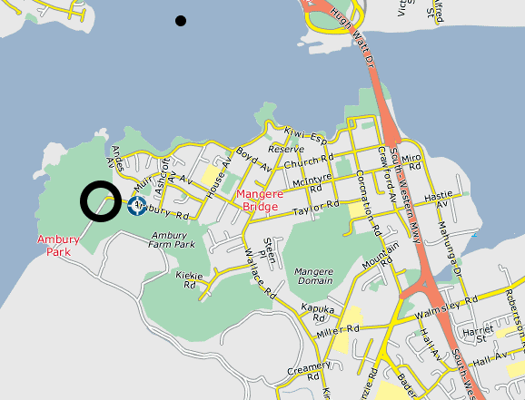
Ambury Regional Park is located just 15 kilometers from Central Auckland and rests on the ash-covered lava flow from Mangere Mountain.

Summary
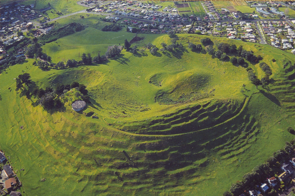
Nearby Mangere Mountain was once the site of large fortified Māori pa and the area now known as Ambury Regional Park was used by Māori for gardening. Mangere Mountain erupted approximately 18,000 years ago and the park sits atop a lava field made fertile by ash from the volcano. The Archaeological record left behind is astounding and, for the most part, can be viewed by the public. In fact, Ambury Regional Park is the only place where publicly owned Maori Rock Art can be found.
Archaeology
In 1981 over 95 separate archaeological sites were recorded. These mostly included stone and midden piles, but some wall structres and borders can be discerned. The most intact group of sites is found in the north eastern region of the park. Stone mounds and garden walls are distinctive features, but groupings of Archaeological remains can be found throughout the coastline. It is said that the archaeological remains are in such quantity that rabbits are constantly unearthing new midden.
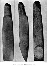
Photog: unknown Maori History
History
Approximately one kilometre south-west of Ambury Regional Park is Puketutu Island. This island is also known as "Motu-a-Hiaroa" (Island of the Long Desired) and is claimed to have been populated by some of the earliest Maori inhabitants of Aotearoa i as far b. ack as 950 A.D.- Tradition has it that one of the earliest travellers from Hawaiki (generally thought to be the Society Islands), Toi-te-hua-tahi, also known as Toi-kairakau, landed his canoe at Whakatane in the Bay of Plenty around 1 125 AD. From there his iwi (people or tribe) spread, reaching the Auckland area (Tamaki-makau-rau) around 1 150 AD and visiting the inhabitants of Motu-a- Hiaroa. Toi's iwi merged with those already inhabiting the area, a people who were known by several names, one being Nga Oho who were the dominant people in the Tamaki-makau-rau area. Motu-a-Hiaroa became an important centre for them. The island was a stronghold, partially isolated and easily fortified, with fertile soil and close to excellent fishing grounds. Motu-a-Hiaroa became prized by the tahgata whenua (people of the land) and the tuahu (ceremonial place) on the island became very important, holding great mana (spiritual importance and prestige) for the people of the surrounding area. It was also known to be a home of the important Tohunga (spiritual leader) Rakataura, and so the summit of the island is called f e Tomata a Rakataura. Motu-a-Hiaroa became so populated that people settled in the surrounding coastal areas, including the land now in Ambury Regional Park. Many of the earliest archaeological sites at Ambury may have been a result of this habitation. The arrival of what is now known as the Great Fleet in Aotearoa occurred around 1350 AD. People from four canoes had an effect on Tamaki-makau-rau history; the Tainui, Arawa, Aotea and the Mataatua. The Tainui, however, became the most important for the Manukau area. The Tainui sailed into the Hauraki Gulf and the Waitemata Harbour and up the Tamaki River. At Otahuhu the canoe was drawn across the portage route into the Manukau Harbour. Continuing past the area where Ambury Regional Park is now located, they made their way to Kawhia. The people settled there and ultimately spread to the Waikato, Hauraki and Tamaki, all of which became great Tainui areas. Following the arrival of the Great Fleet, the history of the Tamaki - Mangere area was one of continuous intertribal struggles. Rich and extensive, with two seas nearby, the isthmus was a much loved area and came to be known as Tamaki-makau-rau (Tamaki, the bride sought by a hundred lovers). Not only was it a desirable area in which to live, but with its portages, it formed a highway for war parties travelling north and south. On all vantage points elaborate fortifications were erected. The people lived in their kainga, or villages, working in the fields nearby and moving to their fighting pa for meetings, celebrations and defence. Cultivations were extensive and taro, hue (gourds) and uwhi (yams) were grown in addition to the main crops of kumara. In addition to agriculture, the Maori lived by hunting and fishing. Mangere Mountain, also known as Te-ara-Pueru, a short distance from Ambury, was one of many large pa on the volcanic cones of the isthmus. Many kainga surrounded the pa at Mangere Mountain and the land now known as Ambury Regional Park was a part of these settlements. From a strategic point of view the pa at Mangere was extremely important as it overlooked the portage between the Manukau and Waitemata harbours, the main route for north - south travel. Canoes would paddle up the Tamaki River, portage across to the Manukau at Otahuhu, canoe again to Waiuku and portage. to the Awaroa River which then led down to the Waikato River. It is claimed that one of the launching points for the canoes lies within the Kiwi Esplanade reserve just to the east of the park where the launching ramps for the Manukau Yacht Club are now situated. Springs close to the foreshore in Ambury provided a convenient fresh water source and may have been utilised by the travellers: Around the 1500's the great Nga Oho leader Hua dominated the Tamaki isthmus. Such was the mana of Hua that he was given the name Hua kai waka - the consumer of canoes. The Wai-o-Hua iwi, later to become important hi the area, descended from Hua. The Wai-o-Hua defended the Tamaki area against outside tribal groups during the 1600's. Maungakiekie (One Tree Hill) was the main citadel of the isthmus with Mangere the chief hill fort. With the elaborate fortifications of the area,, the Wai-o^Hua resisted attacks and by middle the of the eighteenth century the grandson of Hua, the notorious Kiwi Tamaki, led the people. A major conflict with the powerful Ngati Whatua iwi of the north began when Kiwi Tamaki went to the Helensville area at the invitation of the Ngati Whatua. In order to avenge the killing of his ancestors by the Ngati Whatua, Kiwi Tamaki slew many local chiefs. The Ngati Whatua of the Kaipara area retaliated to avenge these deaths. After many years of raids and fighting, the Ngati Whatua took several pa near the Manukau Heads. Kiwi Tamaki and the Wai-o-Hua attacked at Paruroa and a great battle took place in which Kiwi Tamaki and many other Wai-o-Hua and Ngati Whatua leaders were killed. The Ngati Whatua then took control of some of the pa in the Tamaki-makaurau area including Maungakiekie. However the strong pa of Motu-a-Hiaroa (Puketutu Island) and Mangere remained in Wai-o-Hua hands for some tune. Mangere was left unmolested by the Ngati Whatua for some tune, as it was a formidable fortress. However the Wai-o-Hua contacted the people of the Waikato, their aim being to join with them and avenge the conquest of the isthmus by the Ngati Whatua. On learning of this, the Ngati Whatua resolved to destroy the pa. Many attacks were repelled, however eventually even Mangere fell. One night, when the defenders were fatigued with the persistence of the attackers, the Ngati Whatua approached from the north. The Wai-o-Hua had placed large quantities of pipi shells over the pathway entrances into the pa so that they might hear anyone approaching and be warned. The Ngati Whatua however, spread their clothing over the shells and crept silently across them, surprising and finally defeating the Wai-o-Hua. Text taken directly from : Ambury History and Archaeology
Photo: Mangere Bridge Village

