Difference between revisions of "Mount Hobson - Visit"
(Created page with " == Mt Hobson - Remuwera == {{Infobox Sitetovisit | | site_name = Mt Hobson | alternate_name = Ōhinerau (also known as Ōhinerangi and Remuwera) | stars_...") |
|||
| (4 intermediate revisions by the same user not shown) | |||
| Line 1: | Line 1: | ||
| − | == Mt Hobson - | + | == Mt Hobson - Ōhinerau - Visit== |
| Line 19: | Line 19: | ||
===Location:=== | ===Location:=== | ||
{{#display_map: | {{#display_map: | ||
| − | -36. | + | -36.8783,174.7848~Mt Hobson; |
| height= 400px | | height= 400px | ||
| width= 600px | | width= 600px | ||
| Line 28: | Line 28: | ||
===What:=== | ===What:=== | ||
| − | Prehistoric Maori fortification and place of residence built on a volcanic cone. There is | + | Prehistoric Maori fortification and place of residence built on a volcanic cone. There is little on site interpretation. Look out for defensive ditches and terracing for living areas and defence. Kumara storage pits can be seen. |
| − | + | A reservoir on the western side had destroyed part of the site. | |
| − | + | The Hobson name references Captain William Hobson who was the first was the first Governor of New Zealand and co-author of the Treaty of Waitangi. | |
| − | + | There are two entrances off Remuera Rd but parking is difficult. Easier is the lane to the south of the cone. | |
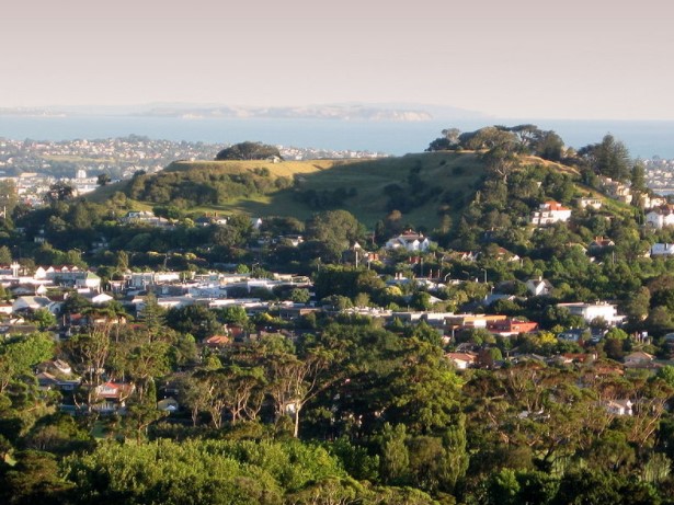
| + | [[Image:Hobson.jpg|framed|The Maunga from the south. Wikimedia, credit: Folash]] | ||
| − | + | <html> | |
| + | <body> | ||
| + | <iframe width="560" height="315" src="https://www.youtube.com/embed/WDEXeYN4ub0?start=346" title="YouTube video player" frameborder="0" allow="accelerometer; autoplay; clipboard-write; encrypted-media; gyroscope; picture-in-picture; web-share" allowfullscreen></iframe> | ||
| + | |||
| + | </body> | ||
| + | |||
| + | </html> | ||
===What else to do there:=== | ===What else to do there:=== | ||
| − | Great views over the inner city and | + | Great views over the inner city and Waitemata Harbour. Nearby are Mt St John, Mt Eden and One Tree Hill. |
| + | |||
| + | Auckland Museum is only a little way away. https://www.aucklandmuseum.com/ | ||
| − | + | Remuera is a small shopping center and Newmarket a much larger one. | |
| Line 51: | Line 60: | ||
[https://www.aucklandcouncil.govt.nz/pages/search.aspx?k=T%C5%ABpuna%20Maunga%20o%20T%C4%81maki Tūpuna Maunga o Tāmaki Makaurau] | [https://www.aucklandcouncil.govt.nz/pages/search.aspx?k=T%C5%ABpuna%20Maunga%20o%20T%C4%81maki Tūpuna Maunga o Tāmaki Makaurau] | ||
| + | {{Wikipedia|Mount Hobson (Auckland)}} | ||
'''References''' | '''References''' | ||
| Line 62: | Line 72: | ||
[[Category:Auckland_Sites_to_Visit]][[Category:AucklandVolcanicCones]] | [[Category:Auckland_Sites_to_Visit]][[Category:AucklandVolcanicCones]] | ||
| + | [[Category:Sites with Drone Video]] | ||
Latest revision as of 21:15, 22 January 2023
Mt Hobson - Ōhinerau - Visit
| SITE TO VISIT | |
|---|---|
| Mt Hobson | |
| Ōhinerau (also known as Ōhinerangi and Remuwera) | |
| | |

| |
| Ethnicity: | Maori |
| Site type: | Pa |
| Where: | Central Isthmus - 15 minutes from the city centre |
| How to get there: | Bus (Check Rideline) or taxi. |
| How Long to allow: | 1 hr walking over the site. |
| Disclaimer | |
Location:


What:
Prehistoric Maori fortification and place of residence built on a volcanic cone. There is little on site interpretation. Look out for defensive ditches and terracing for living areas and defence. Kumara storage pits can be seen.
A reservoir on the western side had destroyed part of the site.
The Hobson name references Captain William Hobson who was the first was the first Governor of New Zealand and co-author of the Treaty of Waitangi.
There are two entrances off Remuera Rd but parking is difficult. Easier is the lane to the south of the cone.
What else to do there:
Great views over the inner city and Waitemata Harbour. Nearby are Mt St John, Mt Eden and One Tree Hill.
Auckland Museum is only a little way away. https://www.aucklandmuseum.com/
Remuera is a small shopping center and Newmarket a much larger one.
Web Info:
Tūpuna Maunga o Tāmaki Makaurau
References

