Difference between revisions of "Hinge Bay"
(→Hinge Bay - Manukau Timber Company Sawmill) |
(→Location and Date) |
||
| (24 intermediate revisions by 2 users not shown) | |||
| Line 1: | Line 1: | ||
| − | == Hinge Bay - Manukau Timber Company Sawmill == | + | == Hinge Bay - Manukau Timber Company Sawmill Q11/472 == |
| − | + | Hinge Bay is the site of a sawmill built by the Manukau Timber Company. It operated from 1891 to 1895. There was an associated wharf and manager's house. The latter still survives as part of an outdoors education camp. The mill was built on the water's edge and the surviving remains include the concrete pile foundations and a steam engine foundation. | |
| − | Hinge Bay is the site of a sawmill built by the Manukau Timber Company. It operated from 1891 to 1895. There was an associated wharf and manager's house. The latter still | ||
{| width="50%" | {| width="50%" | ||
| Line 14: | Line 13: | ||
The site is scheduled for preservation or protection in the '''Auckland Regional Plan: Coastal''' - Site No. 54. | The site is scheduled for preservation or protection in the '''Auckland Regional Plan: Coastal''' - Site No. 54. | ||
| + | ---- | ||
==Summary of Manukau Timber Company Sawmill Conservation Plan== | ==Summary of Manukau Timber Company Sawmill Conservation Plan== | ||
| Line 21: | Line 21: | ||
A conservation plan was prepared for the Auckland Regional Council by [[Law Garry|Garry Law]], Law Associates Ltd, and John Coster, Heritage Works. | A conservation plan was prepared for the Auckland Regional Council by [[Law Garry|Garry Law]], Law Associates Ltd, and John Coster, Heritage Works. | ||
| − | G Law and J Coster 2000 '''Manukau Timber Company Mill, Hinge Bay, Huia (Site Q11/472) Conservation Plan.''' Prepared for the Auckland Regional Council, Law Associates Ltd and Heritage Works. | + | G Law and J Coster 2000 '''Manukau Timber Company Mill, Hinge Bay, Huia (Site Q11/472) Conservation Plan.''' Prepared for the Auckland Regional Council, [http://www.lawas.co.nz/COMPS/archaeol.htm Law Associates Ltd] and Heritage Works. |
| + | |||
| + | [[Image:Hiuax.jpg|thumb|Historic photo]] | ||
| + | |||
| + | The mill was built partly on concrete foundations in the intertidal zone on a boulder beach. Much of these foundations, some including timber baulks are still insitu. Part of the mill was built on the sandy flat behind the beach. An engine foundation exists in that situation as well as what appears to be a base for a boiler. The mill utilised kauri logs from the Waitakere Ranges behind the bay. These were driven by timber dams down several streams. The main source is believed to be the Karamatura Stream, with the logs caught in a boom at the sea front, floated around to the mill and hauled up a ramp to the mill floor. The milled timber was stacked to the west of the mill and shipped out via a light tramway to the wharf. The wharf would not accomodate anything but small vessels at high tide. Some timber was shipped by floating baulks out to larger ships. | ||
| + | |||
| + | The mill machinery is believed to have been erected previously at Karakare. A similar engine base exists there. With a large diameter flywheel the engine was of a dated design when it was erected here. The double chimneys on the historical photograph suggest there were two boilers in use. | ||
| + | |||
| + | [[Image:Huia_2600.JPG|thumb|Map of the site]] | ||
| − | The mill was | + | The mill was in competiton with a much larger mill at Onehunga - also on the Manukau Harbour edge. The Onehunga mill the advantage of road and rail access to central Auckland for its products and no doubt a bigger labour pool. Much larger vessels could also bring logs to Onehunga so its source of timber was also wider. This was the pattern generaly in the Kauri industry - a move to bigger vessels - mostly scows - and large centralised mills. The large mills also had capacity for making weatherboards and joinery mouldings and hence satisfying more of the market. This competiton, combined with the current economic depression, pushed the Manukau Timber Company into receivership. The mill equipment was sold and moved to Waitakere. |
| − | + | There was no sawdust or ash residue at the site suggesting this had been disposed of into the sea. There was no coal waste at the site so the boiler firing was very likely to have been entirely from off-cuts. | |
| − | [[Image: | + | [[Image:Hiua.jpg|thumb|The engine block]] |
| − | + | After this use the site was used for batches by people without any formal right of use of the site. These were removed when the Auckland Regional Council took over the land behind the bay as a regional park in 1972. | |
| − | + | The survey noted some areas of concrete with different constituents from the foundation blocks. These appear to have been later additions to form seawalls for the grounds of the batches. The batch use may have caused some disturbance to the beach terrace and possibly to any archaeology in this area. | |
| − | + | Several of the foundation blocks had been tipped over. Anecdotal evidence pointed to a storm in April 1999 as causing this damage and some erosion to the beach terrace. The surface of the concrete blocks are severely eroded - reflecting the low strength of the concrete, and the wetting / drying environment they are in which enhances surface loss. | |
| − | + | Identified risks to the site were: | |
| − | + | * Tree roots entering recesses and cracks in the engine block and cracking it open - pruning was recommended | |
| − | + | * Rabbit damage to the beach deposits - monitoring and control was recommended | |
| − | + | * Visitor damage - interpretation was recommended to increase public appreciaiton and awareness | |
| + | * Further deterioration of the concrete. No in-situ treatment was considered likley to be effective that did not involve an unacceptably large intervention. No action was recommended. | ||
| + | * Further wave damage. The combination of wind direction and high tide was identified as the risk factor. Sea level rise would make this worse over time. Interventions considered were a wave protection off-shore, burying the site in wave protection stone and relocation of the site to a more protected location. None were considered acceptable. Also considered was protection below a normal engineering standard which might be less intrusive. This was considered likley to fail comprehensively. No action was recommended. | ||
| + | |||
| + | * Erosion of the beach terrace. Monitoring was recommended. | ||
| + | |||
| + | |||
| + | A conservation policy was recommended. Recommendations were made for interpretation. | ||
| + | |||
| + | ---- | ||
| + | |||
| + | Since the plan was prepared further of the foundation blocks have been tipped - presumably by wave action. | ||
| − | |||
---- | ---- | ||
| Line 56: | Line 74: | ||
* The site was used as a sawmill from 1891 to 1895. | * The site was used as a sawmill from 1891 to 1895. | ||
| − | * The investigation for the conservation plan was undertaken in | + | * The investigation for the conservation plan was undertaken in 2000. |
| + | |||
| + | Mouse over markers for captions | ||
| + | |||
| + | {{#display_map: | ||
| + | -37.006657, 174.56416 ~ Sawmill site; | ||
| + | -37.007539, 174.563785 ~ Wharf site; | ||
| + | -37.007556, 174.563141 ~ Mill manager's house; | ||
| + | |||
| + | | height= 400px | ||
| + | | width= 600px | ||
| + | | type=satellite | ||
| + | | zoom=17 | ||
| + | }} | ||
| + | |||
| − | |||
| − | |||
| − | |||
| − | |||
| − | |||
---- | ---- | ||
| Line 80: | Line 107: | ||
==Artefacts== | ==Artefacts== | ||
| − | + | There were glass, ceramic, metal, bakelite, midden bone and imported stone materials noted in the site. They were left insitu. | |
| − | + | ---- | |
| − | |||
| − | |||
| − | |||
==Documents== | ==Documents== | ||
'''Conservation Plan:''' | '''Conservation Plan:''' | ||
G Law and J Coster 2000 Manukau Timber Company Mill, Hinge Bay, Huia (Site Q11/472) Conservation Plan. Prepared for the Auckland Regional Council, Law Associates Ltd and Heritage Works, (unpublished). | G Law and J Coster 2000 Manukau Timber Company Mill, Hinge Bay, Huia (Site Q11/472) Conservation Plan. Prepared for the Auckland Regional Council, Law Associates Ltd and Heritage Works, (unpublished). | ||
[[Category:Auckland]][[Category:Historic]][[Category:Industrial Archaeology]] | [[Category:Auckland]][[Category:Historic]][[Category:Industrial Archaeology]] | ||
| + | [[Category:2000]] | ||
| + | [[Category:West Auckland]] | ||
| + | [[Category:Excavations]] | ||
Latest revision as of 13:22, 4 October 2017
Contents
Hinge Bay - Manukau Timber Company Sawmill Q11/472
Hinge Bay is the site of a sawmill built by the Manukau Timber Company. It operated from 1891 to 1895. There was an associated wharf and manager's house. The latter still survives as part of an outdoors education camp. The mill was built on the water's edge and the surviving remains include the concrete pile foundations and a steam engine foundation.
|
|
There is a guided walk to the site starting at the Huia Museum. The Auckland Regional Council interpretation was undertaken by Caroline Phillips.
The site is scheduled for preservation or protection in the Auckland Regional Plan: Coastal - Site No. 54.
Summary of Manukau Timber Company Sawmill Conservation Plan
A conservation plan was prepared for the Auckland Regional Council by Garry Law, Law Associates Ltd, and John Coster, Heritage Works.
G Law and J Coster 2000 Manukau Timber Company Mill, Hinge Bay, Huia (Site Q11/472) Conservation Plan. Prepared for the Auckland Regional Council, Law Associates Ltd and Heritage Works.
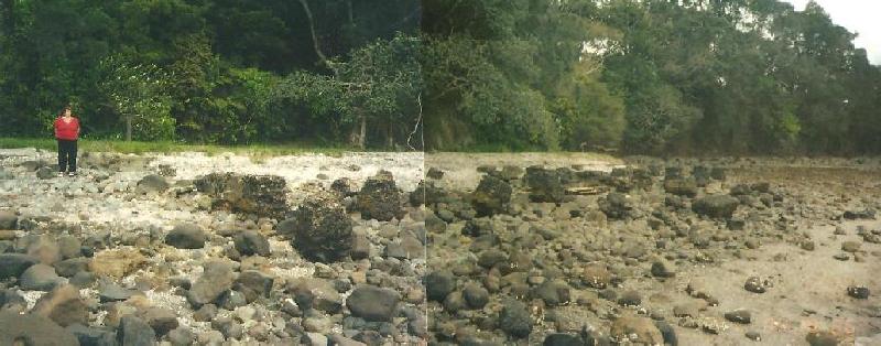
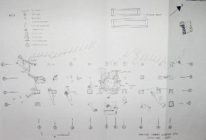
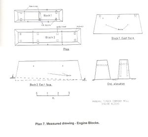
The mill was built partly on concrete foundations in the intertidal zone on a boulder beach. Much of these foundations, some including timber baulks are still insitu. Part of the mill was built on the sandy flat behind the beach. An engine foundation exists in that situation as well as what appears to be a base for a boiler. The mill utilised kauri logs from the Waitakere Ranges behind the bay. These were driven by timber dams down several streams. The main source is believed to be the Karamatura Stream, with the logs caught in a boom at the sea front, floated around to the mill and hauled up a ramp to the mill floor. The milled timber was stacked to the west of the mill and shipped out via a light tramway to the wharf. The wharf would not accomodate anything but small vessels at high tide. Some timber was shipped by floating baulks out to larger ships.
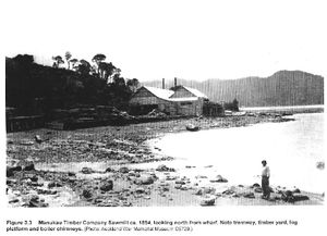
The mill machinery is believed to have been erected previously at Karakare. A similar engine base exists there. With a large diameter flywheel the engine was of a dated design when it was erected here. The double chimneys on the historical photograph suggest there were two boilers in use.
The mill was in competiton with a much larger mill at Onehunga - also on the Manukau Harbour edge. The Onehunga mill the advantage of road and rail access to central Auckland for its products and no doubt a bigger labour pool. Much larger vessels could also bring logs to Onehunga so its source of timber was also wider. This was the pattern generaly in the Kauri industry - a move to bigger vessels - mostly scows - and large centralised mills. The large mills also had capacity for making weatherboards and joinery mouldings and hence satisfying more of the market. This competiton, combined with the current economic depression, pushed the Manukau Timber Company into receivership. The mill equipment was sold and moved to Waitakere.
There was no sawdust or ash residue at the site suggesting this had been disposed of into the sea. There was no coal waste at the site so the boiler firing was very likely to have been entirely from off-cuts.
After this use the site was used for batches by people without any formal right of use of the site. These were removed when the Auckland Regional Council took over the land behind the bay as a regional park in 1972.
The survey noted some areas of concrete with different constituents from the foundation blocks. These appear to have been later additions to form seawalls for the grounds of the batches. The batch use may have caused some disturbance to the beach terrace and possibly to any archaeology in this area.
Several of the foundation blocks had been tipped over. Anecdotal evidence pointed to a storm in April 1999 as causing this damage and some erosion to the beach terrace. The surface of the concrete blocks are severely eroded - reflecting the low strength of the concrete, and the wetting / drying environment they are in which enhances surface loss.
Identified risks to the site were:
- Tree roots entering recesses and cracks in the engine block and cracking it open - pruning was recommended
- Rabbit damage to the beach deposits - monitoring and control was recommended
- Visitor damage - interpretation was recommended to increase public appreciaiton and awareness
- Further deterioration of the concrete. No in-situ treatment was considered likley to be effective that did not involve an unacceptably large intervention. No action was recommended.
- Further wave damage. The combination of wind direction and high tide was identified as the risk factor. Sea level rise would make this worse over time. Interventions considered were a wave protection off-shore, burying the site in wave protection stone and relocation of the site to a more protected location. None were considered acceptable. Also considered was protection below a normal engineering standard which might be less intrusive. This was considered likley to fail comprehensively. No action was recommended.
- Erosion of the beach terrace. Monitoring was recommended.
A conservation policy was recommended. Recommendations were made for interpretation.
Since the plan was prepared further of the foundation blocks have been tipped - presumably by wave action.
Location and Date
Mouse over markers for captions Loading map...
TypeThe site is a steam powered sawmill and related wharf. Team
ArtefactsThere were glass, ceramic, metal, bakelite, midden bone and imported stone materials noted in the site. They were left insitu. DocumentsConservation Plan: G Law and J Coster 2000 Manukau Timber Company Mill, Hinge Bay, Huia (Site Q11/472) Conservation Plan. Prepared for the Auckland Regional Council, Law Associates Ltd and Heritage Works, (unpublished). |


