Difference between revisions of "St Thomas's Ruins - Visit"
(Created page with "== St Thomas's Ruins == {{Infobox Sitetovisit | | site_name = St Thomas's Ruins | alternate_name = | stars_image = Image:Star.gif | type_image1 ...") |
(→St Thomas's Ruins) |
||
| (5 intermediate revisions by the same user not shown) | |||
| Line 6: | Line 6: | ||
| alternate_name = | | alternate_name = | ||
| stars_image = [[Image:Star.gif]] | | stars_image = [[Image:Star.gif]] | ||
| − | | type_image1 = | + | | type_image1 = |
| type_image2 = | | type_image2 = | ||
| − | | ethnicity = | + | | ethnicity = European |
| − | | site_type = | + | | site_type = Church Ruin |
| − | | where = | + | | where = St Heliers eastern suburb of Auckland |
| − | | how_to_get_there = Bus (Check Rideline) or taxi. | + | | how_to_get_there = Bus (Check Rideline) or taxi. 30 minutes from city. |
| how_long_to_allow = 10 minutes | | how_long_to_allow = 10 minutes | ||
}} | }} | ||
| − | + | {{#display_map: | |
| − | + | -36.867534, 174.846055~ Ruins; | |
| − | + | | height= 400px | |
| − | [[File: | + | | width= 600px |
| + | | type=satellite | ||
| + | | zoom=19 | ||
| + | }} | ||
| + | |||
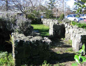
| + | [[File:Stthom.jpg|thumb|right|The ruins.]] | ||
| − | '''Location:''' | + | '''Location:''' |
| − | + | ||
| + | Corner of Kohimarama Rd and St Heliers Bay Rd | ||
| + | |||
| + | '''What:''' | ||
| − | + | Foundations of a church built in the 1840's from Rangitoto basalt and mortar made from sea sand. The mortar weakened and the church eventually collapsed. The ruins are north east of the new church - also built of basalt. The original church was multi-denominational. The church was defended during the 'War in the North' but no sign of these remain. | |
| − | |||
| − | '''What else to do there:''' | + | '''What else to do there:''' |
| − | . | + | |
| + | The St Johns College site nearby has some remarkable heritage buildings of the same age - 1840's - it is a working site so not routinely open to the public but some buildings can be seen from the road. | ||
'''Web info:''' | '''Web info:''' | ||
| + | |||
| + | http://www.aucklandcity.govt.nz/dbtw-wpd/exec/dbtwpub.dll?BU=http://www.aucklandcity.govt.nz/dbtw-wpd/heritageimages/keyword.htm&QF0=ID&QI0=4-3360&MR=1&TN=heritage&RF=FullHTML&RL=0&NP=2&AC=QBE_QUERY | ||
| + | |||
| + | http://www.aucklandcity.govt.nz/dbtw-wpd/exec/dbtwpub.dll?BU=http://www.aucklandcity.govt.nz/dbtw-wpd/heritageimages/keyword.htm&QF0=ID&QI0=1-W455&MR=1&TN=heritage&RF=FullHTML&RL=0&NP=2&AC=QBE_QUERY | ||
| + | |||
| + | http://www.aucklandcity.govt.nz/dbtw-wpd/exec/dbtwpub.dll?BU=http://www.aucklandcity.govt.nz/dbtw-wpd/heritageimages/keyword.htm&QF0=ID&QI0=35-R250&MR=1&TN=heritage&RF=FullHTML&RL=0&NP=2&AC=QBE_QUERY | ||
[[Category:Auckland_Sites_to_Visit]] | [[Category:Auckland_Sites_to_Visit]] | ||
Latest revision as of 21:10, 4 August 2013
St Thomas's Ruins
| SITE TO VISIT | |
|---|---|
| St Thomas's Ruins | |
| ' | |
| | |
| Ethnicity: | European |
| Site type: | Church Ruin |
| Where: | St Heliers eastern suburb of Auckland |
| How to get there: | Bus (Check Rideline) or taxi. 30 minutes from city. |
| How Long to allow: | 10 minutes |
| Disclaimer | |
Loading map...
Location:
Corner of Kohimarama Rd and St Heliers Bay Rd
What:
Foundations of a church built in the 1840's from Rangitoto basalt and mortar made from sea sand. The mortar weakened and the church eventually collapsed. The ruins are north east of the new church - also built of basalt. The original church was multi-denominational. The church was defended during the 'War in the North' but no sign of these remain.
What else to do there:
The St Johns College site nearby has some remarkable heritage buildings of the same age - 1840's - it is a working site so not routinely open to the public but some buildings can be seen from the road.
Web info:
