Difference between revisions of "Copper Mine Kawau Island - Visit"
(→Copper Mine, Kawau Island) |
(→Copper Mine, Kawau Island) |
||
| Line 24: | Line 24: | ||
{{#display_map: | {{#display_map: | ||
| − | -34.983913, 173.525298~Rangikapiti Pa | + | -34.983913, 173.525298~Rangikapiti Pa |
-36.435716, 174.820633~ Copper Mine, Kawau Island, Auckland | -36.435716, 174.820633~ Copper Mine, Kawau Island, Auckland | ||
-36.43026, 174.818401~ Mansion House | -36.43026, 174.818401~ Mansion House | ||
| − | -36.419936, 174.837354~ Smelting House | + | -36.419936, 174.837354~ Smelting House; |
| height= 400px | | height= 400px | ||
| width= 600px | | width= 600px | ||
Revision as of 20:33, 4 August 2013
Copper Mine, Kawau Island
| SITE TO VISIT | |
|---|---|
| Copper Mine, Kawau Island | |
| - | |
| | |

| |
| Ethnicity: | European |
| Site type: | Mine |
| Where: | Mine Point - southern side of island. |
| How to get there: | There is a regular ferry from the Sandspit to Mansion House Bay. It's a half hour walk from there. |
| How Long to allow: | 30 minutes at the site. |
| Disclaimer | |
<googlemap lat="-36.435232" lon="174.820504" zoom="15"> -36.435716, 174.820633, Copper Mine, Kawau Island, Auckland -36.43026, 174.818401, Mansion House -36.419936, 174.837354, Smelting House </googlemap>
Loading map...
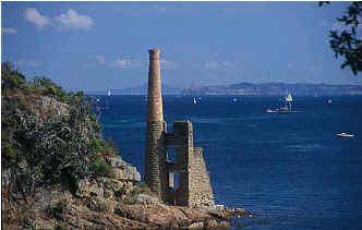
What: Mine engine house remains. Mining commenced in the 1840s.Interpretation at Mansion House.
Web Info: http://www.doc.govt.nz/templates/page.aspx?id=34056
What else to do there: Governor Grey's mansion at Mansion House Bay, Copper smelting house in bay on opposite side of harbour from Mansion House - see Googlemap.
