Difference between revisions of "Albert Barracks - Visit"
| Line 22: | Line 22: | ||
-36.851243, 174.769768, Albert Barracks | -36.851243, 174.769768, Albert Barracks | ||
</googlemap> | </googlemap> | ||
| + | |||
| + | {{#display_map: | ||
| + | -36.8511505365655,174.76979707368628 | ||
| + | ~Title:Albert Barracks Wall | ||
| + | ~Remnant of the wall. | ||
| + | ~ | ||
| + | ~ | ||
| + | ~(Displayed text) Albert Barracks Wall (or can leave blank); | ||
| + | | height= 400px | ||
| + | | width= 600px | ||
| + | | type=satellite | ||
| + | | zoom=14 | ||
| + | }} | ||
| + | |||
| + | |||
Revision as of 18:45, 4 August 2013
Contents
Albert Barracks
| SITE TO VISIT | |
|---|---|
| Albert Barracks | |
| - | |
| | |

| |
| Ethnicity: | European |
| Site type: | Fortification |
| Where: | Behind the library building in the Auckland University grounds, east of Albert Park |
| How to get there: | In the central city, Alfred St. |
| How Long to allow: | 15 minutes. |
| Disclaimer | |
Location:
<googlemap lat="-36.850677" lon="174.769853" zoom="17"> -36.84846, 174.763332, Auckland, New Zealand -36.851243, 174.769768, Albert Barracks </googlemap>
Loading map...
What:
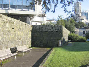
Stone defensive wall of an 1846 military barracks from New Zealand Wars.
Web Info:
http://www.historic.org.nz/TheRegister/RegisterSearch/RegisterResults.aspx?RID=12

