Difference between revisions of "Fort Takapuna - Visit"
(Created page with " == Fort Takapuna == {{Infobox Sitetovisit | | site_name = Fort Takapuna | alternate_name = - | stars_image = Image:Star.gif | type_image1 ...") |
|||
| Line 1: | Line 1: | ||
| − | |||
== Fort Takapuna == | == Fort Takapuna == | ||
| Line 16: | Line 15: | ||
}} | }} | ||
| + | |||
| + | <googlemap lat="-36.814593" lon="174.806085" zoom="17"> | ||
| + | -36.81516, 174.805763, Fort Takapuna | ||
| + | </googlemap> | ||
| + | |||
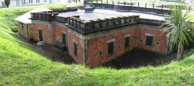
| + | [[File:Forttaka.jpg|framed|The Victorian bunkers]] | ||
== What: == | == What: == | ||
| − | + | ||
| + | Harbour fortifications built from the 19th century Russian scare to the second world war. Disappearing gun pits, tunnels to magazines. Good interpretation. | ||
== Web Info == | == Web Info == | ||
| + | |||
: http://www.doc.govt.nz/templates/page.aspx?id=34054 | : http://www.doc.govt.nz/templates/page.aspx?id=34054 | ||
Revision as of 17:50, 11 December 2010
Fort Takapuna
| SITE TO VISIT | |
|---|---|
| Fort Takapuna | |
| - | |
| | |

| |
| Ethnicity: | European |
| Site type: | Harbour defences |
| Where: | Mine Point - southern side of island. |
| How to get there: | Narrow Neck Beach then walk 300 m south along the cliff edge. |
| How Long to allow: | 1 Hr |
| Disclaimer | |
<googlemap lat="-36.814593" lon="174.806085" zoom="17"> -36.81516, 174.805763, Fort Takapuna </googlemap>
What:
Harbour fortifications built from the 19th century Russian scare to the second world war. Disappearing gun pits, tunnels to magazines. Good interpretation.
Web Info
4d Canvas have produced a virtual reality model of the defences - see http://www.4dcanvas.com/portfolio.html
