Difference between revisions of "North Head - Visit"
(Created page with "== North Head == <googlemap lat="-36.826531" lon="174.81205" zoom="16"> -36.847385, 174.765735, Auckland, New Zealand -36.827665, 174.812028, North Head </googlemap> [[File:Nor...") |
|||
| Line 1: | Line 1: | ||
== North Head == | == North Head == | ||
| + | {{Infobox Sitetovisit | | ||
| + | |||
| + | | site_name = North Head | ||
| + | | alternate_name = - | ||
| + | | stars_image = [[Image:Twostar.gif]] | ||
| + | | type_image1 = [[Image:Fort.gif]] | ||
| + | | type_image2 = | ||
| + | | ethnicity = European | ||
| + | | site_type = Coastal defence | ||
| + | | where = The inner north entrance to Auckland Harbour. | ||
| + | | how_to_get_there = Bus or ferry to Devonport (Ferry 15 minutes from central city) (Check Rideline) - with a 15 minute walk to North Head. | ||
| + | | how_long_to_allow = 1 hr at the site. | ||
| + | |||
| + | }} | ||
<googlemap lat="-36.826531" lon="174.81205" zoom="16"> | <googlemap lat="-36.826531" lon="174.81205" zoom="16"> | ||
| Line 7: | Line 21: | ||
[[File:North head.jpg|right]] | [[File:North head.jpg|right]] | ||
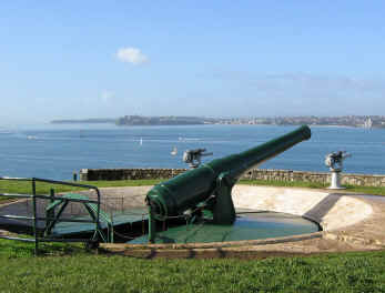
| − | What: Harbour fortifications built on volcanic cone dating from the 19th century Russian scare to the second world war. Disappearing gun, tunnels to magazines, signalling guns. Some interpretation. A torch is handy but not essential. | + | '''What:''' Harbour fortifications built on volcanic cone dating from the 19th century Russian scare to the second world war. Disappearing gun, tunnels to magazines, signalling guns. Some interpretation. A torch is handy but not essential. |
| − | |||
| − | Web Info: http://www.doc.govt.nz/ | + | '''Web Info:''' http://www.doc.govt.nz/templates/trackandwalk.aspx?id=36810 |
| − | templates/trackandwalk.aspx?id=36810 | ||
4d Canvas have produced a virtual reality model of the defences - see http://www.4dcanvas.com/portfolio2.html | 4d Canvas have produced a virtual reality model of the defences - see http://www.4dcanvas.com/portfolio2.html | ||
| − | + | '''What else to do there:''' Great views over Auckland's busy harbour. Cafes and antique shops in Devonport. Naval Museum at naval base. | |
| − | |||
| − | |||
| − | + | [[Category:Auckland_Sites_to_Visit]][[Category:Coastal Defences]] | |
Revision as of 17:20, 28 August 2010
North Head
| SITE TO VISIT | |
|---|---|
| North Head | |
| - | |
| | |

| |
| Ethnicity: | European |
| Site type: | Coastal defence |
| Where: | The inner north entrance to Auckland Harbour. |
| How to get there: | Bus or ferry to Devonport (Ferry 15 minutes from central city) (Check Rideline) - with a 15 minute walk to North Head. |
| How Long to allow: | 1 hr at the site. |
| Disclaimer | |
<googlemap lat="-36.826531" lon="174.81205" zoom="16"> -36.847385, 174.765735, Auckland, New Zealand -36.827665, 174.812028, North Head </googlemap>
What: Harbour fortifications built on volcanic cone dating from the 19th century Russian scare to the second world war. Disappearing gun, tunnels to magazines, signalling guns. Some interpretation. A torch is handy but not essential.
Web Info: http://www.doc.govt.nz/templates/trackandwalk.aspx?id=36810
4d Canvas have produced a virtual reality model of the defences - see http://www.4dcanvas.com/portfolio2.html
What else to do there: Great views over Auckland's busy harbour. Cafes and antique shops in Devonport. Naval Museum at naval base.
